
Mapping, If Not Turning, the Tide
This article comes to us from Voice of San Diego, a journalistic nonprofit.
When a portion of the street near Midway Drive and Barnett Avenue in the Midway district flooded at the end of November, San Diego police moved quickly to rule out the usual flooding suspect: a broken water main.
The flooding, police said, was the result of a high ocean tide surging into the storm drain system.
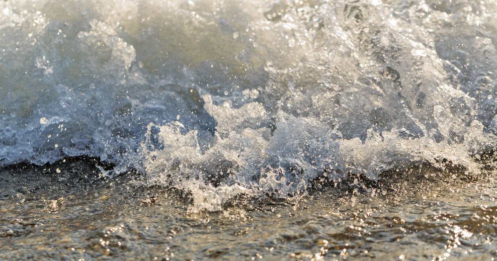
On the morning of Dec. 23, the tide flowed over the beach at La Jolla shores, crested the seawall and flooded the boardwalk and parking lot. The next day, waves created by the incoming king tide.
They are so-called ŌĆ£king tides,ŌĆØ the highest tides of the year. that typically happens throughout the November-February winter season; the next such tide is expected to arrive the week of Jan. 21.
But the water is reaching farther into San Diego than ever before. In late November, the swells reached historic heights.
Local scientists say the king tides are getting more severe and causing flooding more often. It could be a harbinger of a much larger problem: rising sea levels due to climate change.
, the California Ocean Protection Council reported that the tide stations monitored by the , including those off of San Diego, recorded the highest sea levels ever on Nov. 25. The information gathered by the local tide stations cataloged sea levels up to half a foot higher than predicted. Combined with the El Nino and the warm oceanic conditions, these record-breaking water levels resulted in the abnormally large king tide and the Midway district flooding.
King tides happen naturally and have been a consistent annual event throughout San DiegoŌĆÖs history. Tidal forces typically push an inch or so of water up a storm drain or over a barrier to flood streets and parking lots. Once the tide goes back out, the water recedes, causing little damage.
But experts say itŌĆÖs getting worse.
ŌĆ£California broke a record late last month: sea levels at several tide stations in southern California reached higher elevations than ever measured before, including during major storms,ŌĆØ Abe Doherty, CaliforniaŌĆÖs climate change policy adviser,in a memo about these findings published last month by the OPC. ŌĆ£Water levels were higher than the ŌĆ£King TidesŌĆØ that were predicted by the National Oceanic and Atmospheric Administration, due to the ongoing El Ni├▒o, warm ocean temperatures and a minor storm.ŌĆØ
: Melting polar ice caps are raising the volume of water in the worldŌĆÖs oceans; a large and persistent patch of abnormally-warm surface water in the Pacific off the West Coast known as ŌĆ£the BlobŌĆØ which is increasing the temperature and activity of the ocean surface; and most immediately, this winterŌĆÖs large El Ni├▒o system, an irregular atmospheric event in the Pacific Ocean that affects barometric pressure and impacts seasonal weather systems.
ItŌĆÖs having an effect on the local coastline. ŌĆ£Sea levels along the California coast have quite consistently been running several inches in excess of astronomical tide prediction,ŌĆØ said Dan Cayan, a climatologist at the Scripps Institute of Oceanography. ŌĆ£During the king tide late last month, La Jolla and other California coastal tide gage stations experienced record high levels. Fortunately, the minor storm was void of big waves.ŌĆØ
During tidal flooding, itŌĆÖs the larger and more powerful waves created by storm surges which cause most structural damage. Higher tide levels give these waves greater access to areas inland.
Waves off San DiegoŌĆÖs beaches are already stronger in the winter than in the summer because of heavier winds and barometric pressure changes of seasonal storms. Combine those factors with the additional pressure changes of the El Ni├▒o system and the increasing volume of seawater, and you have a perfect formula for flooding. Similar circumstances in the resulted in historic flooding in San Diego and other areas of the state, causing millions of dollarsŌĆÖ worth of damage.
The recent stronger-than-average king tides and accompanying flooding serve as a sign of the impact sea level rise and future El Ni├▒os might have on the San Diego coastline. ŌĆ£It is highly likely that global climate will warm, and in response, coastal flooding will increase in frequency and intensity over the next several decades,ŌĆØ said Cayan.
And even though El Ni├▒o is a short-term event, local tide surges could continue after itŌĆÖs over, Doherty believes.
ŌĆ£Combining El Ni├▒o and the Blob, sea level anomalies seem likely to reach average levels of 1 foot this early winter and continue until Spring 2016, lower in the Summer 2016 and rise again temporarily during Fall 2016,ŌĆØ Doherty ┬Ā(emphasis his). ŌĆ£The anomalous sea levels that California is experiencing this fall and that will likely be sustained through spring are approaching longer period increased levels that are projected under climate change for mid-century.ŌĆØ
Exactly how severe those changes will be remains unclear ŌĆō thereŌĆÖs not much data on past events. While the NOAA tide stations have been recording sea level fluctuations off of San Diego since 1906, the record on the location and strength of tidal flooding incidents is sporadic at best. Oceanographers at Scripps say theyŌĆÖre working to correct this.
The Coastal Data Information Program at Scripps is building an online database and digital map documenting tidal flooding. One of the projectŌĆÖs goals involves matching photographs of flooding in early 20th century San Diego with wave and tide conditions recorded in newspapers, and other sources.
Several environmental groups have also collaborated to create the, a ŌĆ£citizen scientistŌĆØ-based program dedicated to collecting photo data on king tides along the stateŌĆÖs coastline. Even with an only partially complete collection of data, the consensus of expert researchers and environmental organizations contacted for this story is we will face severe impacts in coastal areas.
ŌĆ£In my opinion, our SoCal beaches are in for a world of hurt over the next decades,ŌĆØ said Robert Guza, a Scripps professor of oceanography. ŌĆ£ItŌĆÖs a matter of when, not if. An El Ni├▒o temporarily raises sea level by roughly the equivalent of 25 years of normal sea level rise. So this year is an interesting glimpse into the near future.ŌĆØ
Unfortunately, solutions to future flooding are equally ambiguous. Lower-lying areas such as La Jolla, Mission Beach and Imperial Beach remain vulnerable. Local coastal marshes and sand barriers on the beaches help absorb the impact of tidal rises and storm surges, but theyŌĆÖve been diminished by natural forces and human development.
Artificial barriers such as seawalls and storm drains can help mitigate the damage from flooding, but theyŌĆÖre already failing to restrain the higher tides, and.
King tides and the flooding they cause demonstrate how rising sea levels affect San Diego. While itŌĆÖs unclear as to whether the city faces sudden, destructive inundations or a slow tidal creep that gradually consumes the current sea level area of the coastline, itŌĆÖs a scientific certainty that this current winterŌĆÖs rise will be the new normal within a few decades. If a more permanent solution isnŌĆÖt found, San DiegoŌĆÖs scenic beaches may become a thing of the past.
This story originally appeared in .
More ╣·▓·╩ėŲĄ the Authors
Related

“Getting the Golden Ticket”: Participants’ Perspectives on Lexington’s First Assembly

Civic Assemblies: A Framework for Community Colleges

DonŌĆÖt START Now
